survey conducted by
Directorate for the Analysis,
Prevision and Agricultural Statistics (DAPSA)Annual Agricultural Survey

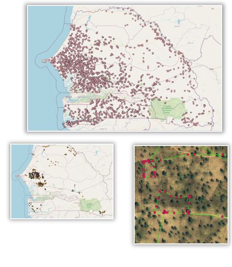
In Senegal, the official Annual Agricultural Survey (AAS) is a list frame survey that covers the entire country. In 2018, 2000 holdings were selected through a stratified sampling approach from the 526,000 holdings in Senegal, representing approximately 0.4% of the total holdings. Within each holding, farmers were interviewed (crop type, area and production for the main season crops). GPS coordinates are gathered at the parcel-level and parcel area is measured.
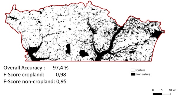
National cropland map at 10-m resolution
This map relied on the AAS 2018, adding a small buffer around each GPS point at parcel-level. Around 3000 additional samples of non-cropland classes were collected by visual interpretation of Very High Resolution imagery.

Accurate crop type mapping was only possible over a smaller region where parcels boundaries were recorded (instead of GPS points).
Per pixel random forest classification based on Sentinel-2 time series
Marginal tuning of the agricultural survey to improve crop type mapping in Nioro
A specific in situ data collection took place in the department of Nioro in 2020, with the support of DAPSA and FAO (joining forces through the EO-Stat initiative), with the following objectives:
- Making the survey protocol more compatible with EO and reinforcing DAPSA expertise
- Collecting parcels boundaries
- Comparing GPS and tablets for parcels boundaries recording
- Collecting additional information on the ground to facilitate the EO integration
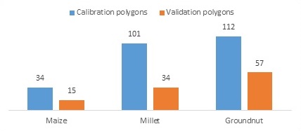
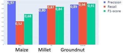
In total, 353 crop polygons were collected in Nioro, as well as 50 non-crop polygons. This dataset was split for calibration and validation, the calibration dataset containing 247 crop polygons and the 50 non-crop polygons.
A new cropland map was produced, with still very high accuracy. More importantly, this in situ dataset allowed delivering an accurate crop type map over the department. The accuracy of maize was not good, mainly due to the small number of samples but it is quite satisfactory for millet and groundnut.
Per pixel random forest classification based on Sentinel-2 time series (01/05-31/12). Overall accuracy: 84,8%
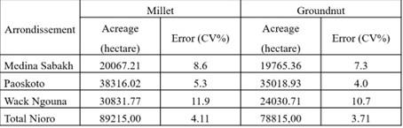
Crop type map for enhanced crop acreage statistics in Nioro
Millet and groundnut acreage statistics were estimated by coupling the crop type map and the in situ dataset and these estimates were compared to the official statistics obtained by only the in situ data. This comparison demonstrates how EO can help reducing the standard error and thus improving the acreage estimates.
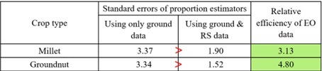
Having a crop type map also allows estimating acreage statistics at the arrondissement (district) level, which is not possible by relying only on ground survey because there is not enough samples.